and Chasing
[Index][Archives]
Severe Hailstorm Chase, Wollongong: Tuesday 1st August 2000
by Andrew Godsman
| Storm News and Chasing [Index][Archives] |
Severe Hailstorm Chase, Wollongong: Tuesday 1st August 2000 by Andrew Godsman |
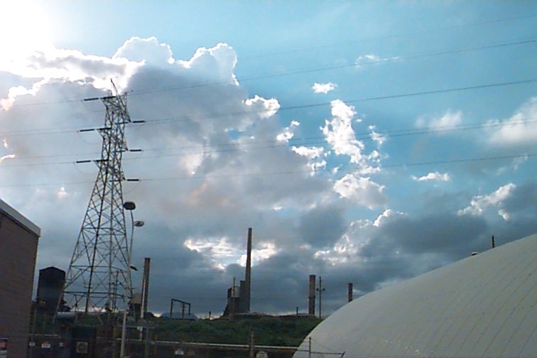 Also, further up the coast, probably around Cambelltown/Camden area was another
cell in a slightly earlier stage of development, ie no anvil. The prevailing upper
winds seemed to be from the SW judging by the anvil direction, but mid level winds
seemed N, it was hard to read, but that was my impression looking at clouds at
different levels.
Also, further up the coast, probably around Cambelltown/Camden area was another
cell in a slightly earlier stage of development, ie no anvil. The prevailing upper
winds seemed to be from the SW judging by the anvil direction, but mid level winds
seemed N, it was hard to read, but that was my impression looking at clouds at
different levels.
So back into the
office with some light rain, I decided it was time to leave work for the half
hour ride home. By this stage it was 3:30pm, and I was treated to a few CG's from
the storm west of Mt Kembla, which seemed to be travelling north at a rate which
matched my progress by bicycle. The rain got progressively heavier as I neared
home at North Wollongong, and thunder was quite regular overhead, which I must
assume was from anvil crawlers. I arrived home just after 4:00pm, attempted to
take a couple of lightening shots from my balcony, which was no good. 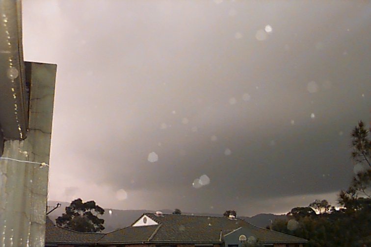
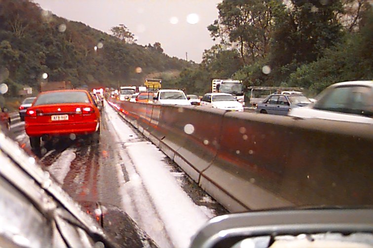 As the storm seemed to clear Mt Ousley I decided to chase the back of it north.
Arriving near the top of Mt Ousley, traffic slowed, and there was a layer of hail
all over the road. The first accident on southbound lanes was slowing things up.
As I was driving, I was taking pictures, some with the digital camera I had brought
home from work, others with my 35mm. Over the top of Mt Ousely and I was treated
to a surreal mammatus shot (which was blurred on film) and heaps more hail, but
the storm was getting away. An overturned car under the Picton Rd overpass again
slowed traffic as the hail started coming down again. Just after this I was stopped
in the northbound lanes by two lanes of traffic refusing to go past the scene
of a15 car accident on the southbound lanes.
As the storm seemed to clear Mt Ousley I decided to chase the back of it north.
Arriving near the top of Mt Ousley, traffic slowed, and there was a layer of hail
all over the road. The first accident on southbound lanes was slowing things up.
As I was driving, I was taking pictures, some with the digital camera I had brought
home from work, others with my 35mm. Over the top of Mt Ousely and I was treated
to a surreal mammatus shot (which was blurred on film) and heaps more hail, but
the storm was getting away. An overturned car under the Picton Rd overpass again
slowed traffic as the hail started coming down again. Just after this I was stopped
in the northbound lanes by two lanes of traffic refusing to go past the scene
of a15 car accident on the southbound lanes.
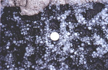 Some people even stopped in the emergency lane, stopping any progress, even for
emergency vehicles arriving at the scene. While I was stopped, hail began falling
quite heavily as the last of the storm went overhead, most hail was up to around
8-10mm in diameter. Finally traffic was driven on by the police and I got to Bulli
tops in time for a spectacular lightening show.
Some people even stopped in the emergency lane, stopping any progress, even for
emergency vehicles arriving at the scene. While I was stopped, hail began falling
quite heavily as the last of the storm went overhead, most hail was up to around
8-10mm in diameter. Finally traffic was driven on by the police and I got to Bulli
tops in time for a spectacular lightening show. 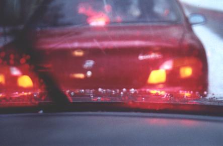
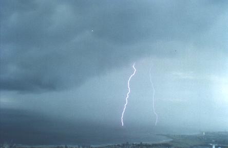
The storm had travelled out to sea, off the Bellambi/Wonoona area. The hail shafts off the back were distinct after what I had just been through, and were not part of the main storm.
The lightening
seemed to be increasing in frequency as well. But the storm shape interested me.
The front end seemed much lower than the rear, with a solid precipitation shaft
to define it from the surrounding low cloud. I hung 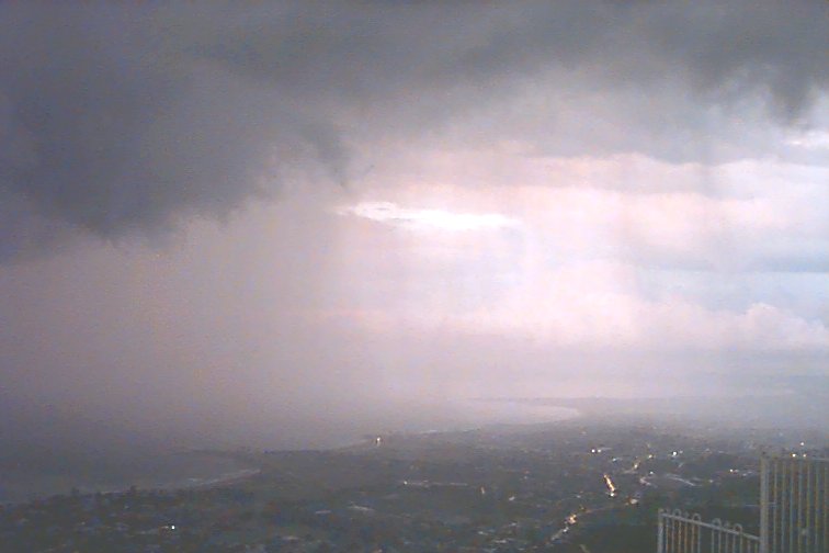 around for about half an hour, until dark, and my last shot on the film.
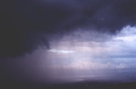
Making my way
home was very painful, it took 25 minutes to crawl 1km to Bulli Pass. In this
time another electrically active storm neared from the west, and light hail was
beginning to fall as I came down Bulli Pass. 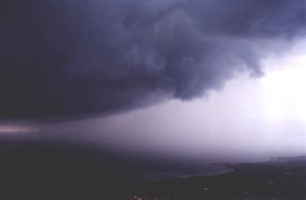 Then it was an easy drive home, with hail apparent in the median strip along the
Northern Distributor near Corrimal, as tendrils of mist floated out across the
road.Then the lightening continued at home for another hour, some within 600m
(2 sec between cg and boom). Also, a very heavy period of rain with some light
hail to finish off the show at around 7:30pm. Some quite nice looking cb's off
the coast this morning, with anvils. So with a forecast for developing showers
about lunchtime, I can only hope for something akin to yesterday to again develop,
as I have the car today.
Then it was an easy drive home, with hail apparent in the median strip along the
Northern Distributor near Corrimal, as tendrils of mist floated out across the
road.Then the lightening continued at home for another hour, some within 600m
(2 sec between cg and boom). Also, a very heavy period of rain with some light
hail to finish off the show at around 7:30pm. Some quite nice looking cb's off
the coast this morning, with anvils. So with a forecast for developing showers
about lunchtime, I can only hope for something akin to yesterday to again develop,
as I have the car today. 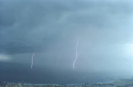
 Making my way home was very painful, it took 25 minutes to crawl 1km to Bulli
Pass. In this time another electrically active storm neared from the west, and
light hail was beginning to fall as I came down Bulli Pass. Then it was an easy
drive home, with hail apparent in the median strip along the Northern Distributor
near Corrimal, as tendrils of mist floated out across the road. Then the lightning
continued at home for another hour, some within 600m (2 sec between cg and boom).
Also, a very heavy period of rain with some light hail to finish off the show
at around 7:30pm.
Making my way home was very painful, it took 25 minutes to crawl 1km to Bulli
Pass. In this time another electrically active storm neared from the west, and
light hail was beginning to fall as I came down Bulli Pass. Then it was an easy
drive home, with hail apparent in the median strip along the Northern Distributor
near Corrimal, as tendrils of mist floated out across the road. Then the lightning
continued at home for another hour, some within 600m (2 sec between cg and boom).
Also, a very heavy period of rain with some light hail to finish off the show
at around 7:30pm.
Some quite nice looking cb's off the coast this morning, with anvils. So with a forecast for developing showers about lunchtime, I can only hope for something akin to yesterday to again develop, as I have the car today.
|
Document: 0008-01.html
Updated: 2nd November, 2001 |
[Australian Severe Weather index] [Copyright Notice] [Email Contacts] [Search This Site] |